Product
A workspace, not a chat box.
You watch the analysis happen. The reasoning streams, the map restyles itself, the layers stay open to inspection, and what comes out the other end keeps its sources.
- The reasoning streams as it runs
- Every step lands on the live map
- Your layers stay inspectable
01 / The anatomy
Four parts, and none of them are hidden from you.
Most AI tools give you a text box and a conclusion. Curated gives you the working surface as well.
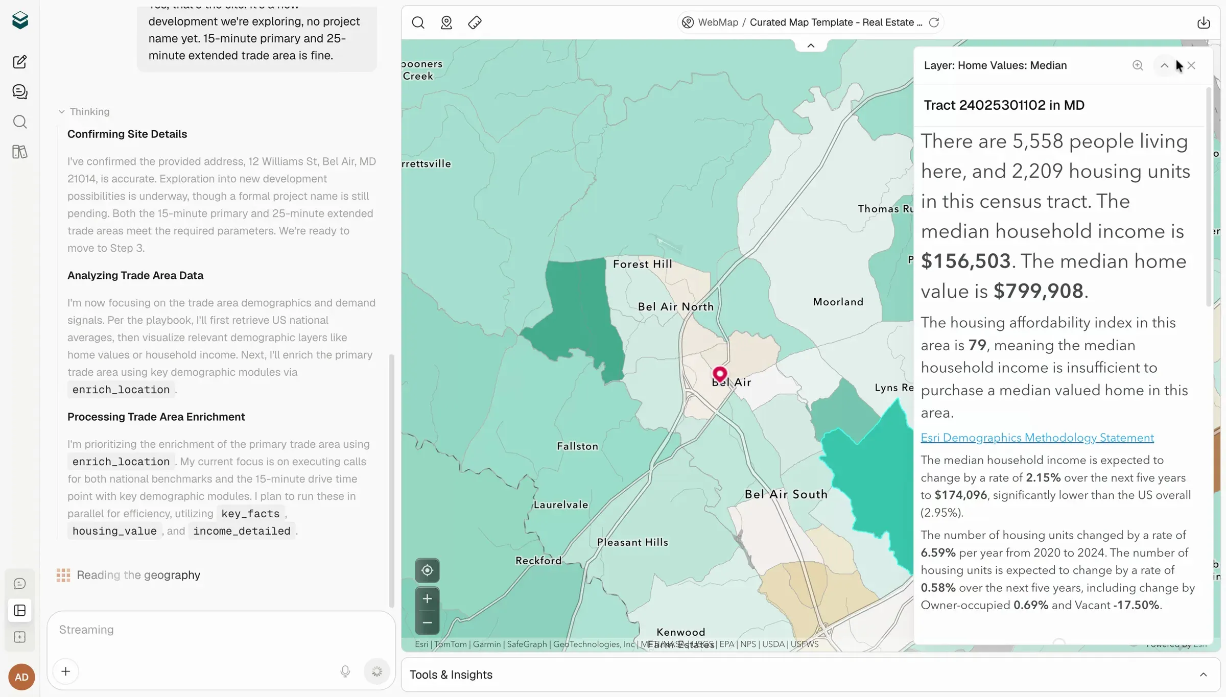
- 01
The conversation
Where the question goes in, and where the reasoning streams back out while it happens.
- 02
The map
Not an illustration of the answer. The place the analysis actually runs, restyling itself as it goes.
- 03
Layers and records
Every layer, its attribute table, its related records and its attachments. Inspectable, like any GIS tool.
- 04
The artifact
The report or PlaceStory™ the session produced, kept with the question and the sources that made it.
02 / Watch it work
It shows its work while it is working.
The reasoning streams as it happens: which tool it reached for, which layer it loaded, what it is enriching. And every step lands on the map, not as a summary afterwards but as it goes.
If it does something you would not have done, you see it at the moment it does it.
- Resolving the address
- Building the 10-minute drive time
- Enriching demographics and spending
- Finding competitors in the trade area
- Styling the layer by predominance
03 / It does real GIS work
Your layers stay layers. Not a picture of layers.
A GIS professional can open the table, follow the related records, and check the attachments. Nothing is flattened into a screenshot on the way through.
Attribute tables
Open any layer's table, sort it, and filter it. The data underneath is never hidden from you.
Related records
Follow a feature through to the records related to it, the way your portal already models them.
Attachments
Photos, permits, PDFs already attached to a feature come through with it.
Dashboards
ArcGIS Dashboards render natively, with real charts, inside the workspace.
04 / Bring anything in
Drop it into the conversation and keep going.
Spreadsheets and documents
Drop in a site list or a report and Curated reads it into the conversation.
Images
Paste a screenshot, a site photo or a scanned map, and it can see what is in it.
The live web, cited
Web-backed claims come back with the sources attached, as citations you can open.
05 / Under your governance
It runs on your terms, not ours.
Curated is model-agnostic. If your organization has already decided which model it trusts, that decision stands.
- Bring your own model keys
- Sign in with your own ArcGIS account
- Isolated per organization
- Usage you can see, not a black box
06 / Where the work lives
A chat box forgets. A workspace does not.
Every question, every answer, and every artifact stays in the workspace, along with the playbook that ran and the sources it used.
Six months later, when somebody asks why you passed on that site, the answer is still there, and it still shows its work.
- Every question you have asked
- Every report and PlaceStory it produced
- Which playbook ran, and on what data
- Searchable, so a decision can be re-opened
The things people ask before they let us near their data.
-
Does this replace our GIS team?
No. Your GIS team is who connects it, governs it, and decides what the rest of the business is allowed to see. Curated takes the requests they never had capacity for and hands the routine ones back, so their time goes to the work only they can do.
-
We already have ChatGPT or Claude. Why would we need this?
Those models are excellent and they will keep getting better. They also have never seen your portfolio, do not know your criteria, cannot run an Esri drive-time enrichment, and cannot show you the geography behind a number so you can argue with it. Curated is built to do the parts they structurally cannot.
-
Do you train models on our data?
Never. Not now, and not on a future roadmap.
-
Which model does Curated run on?
Curated is model-agnostic. We have tuned it against the models we think perform best on this work, but if your organization has standardized on a different one, or wants to bring its own keys, that works.
-
Do we need ArcGIS to use it?
No, but it is better with it. Sign in with your own ArcGIS account and Curated works from the layers and permissions you already have. Without it, Curated starts from its own spatial foundation.
-
There is no playbook for our vertical. What then?
Then we write one with your team, from the way you already decide. That is how most of the existing playbooks came to exist.
Bring us a real question. We will answer it on your ground.
A live walkthrough with a solutions engineer, run on the market you actually care about rather than a prepared demo dataset.
Twenty minutes, with the map and the method visible the whole way.